Two-way exchange of weather data can help people in lower income countries
weather
Two-way flows of data between local, regional, and international meteorological centers have high value for social and economic development.
The need for weather and climate information is growing rapidly as people are becoming more vulnerable to natural hazards, including those exacerbated by climate change. To support economic and social development, all countries need to have access to sufficiently accurate, reliable, and understandable weather, water, and climate data (as stated in the Sustainable Development Goals).1 This is the case everywhere, but particularly in low- and middle-income countries, which are bearing the brunt of losses from natural hazards.2
Scientific and technological advances have brought weather prediction systems to a level where they can provide weather intelligence to inform the decisions of individuals and groups of individuals.3 But such data are useful for decision-making only if more high-quality observational data are shared, assimilated, or used to adjust model outputs. While satellites provide most of the data for models, local data play several critical roles. Scientists from national meteorological services work with regional and global centers to calibrate global models at national and local scales.
The more local data are shared internationally, the better the weather predictions produced by global centers can be applied locally. Exchanging more and better data internationally and doing so more frequently have many direct benefits, yielding better-performing models, more accurate local forecasts, and improved verification of forecasts, helping to monitor, improve, and compare the quality of forecasts and forecasting systems.
Recognizing the benefit of sharing national data with regional and global forecasting centers, Ukraine recently increased the number of weather stations reporting data to the European Centre for Medium-Range Weather Forecasts (ECMWF) from 30 to 130.4 The extra data produced by these stations will help to improve global forecasts and thus regional and national forecasts. In particular, local observations of near-surface temperature and humidity will improve estimates of soil moisture, which influence regional and global forecasts of near-surface temperature and rainfall. Additional data on snow depth from Denmark, Hungary, the Netherlands, Romania, Sweden, and Switzerland have improved forecasts of air temperature in the northern hemisphere.
More data are now being shared in real time between ECMWF and all 37 countries participating in the Regional Integrated Multi-Hazard Early Warning System for Africa and Asia (RIMES).5 The Bangladesh Meteorological Department, for example, has increased from 10 to 32 the number of stations sharing observational data taken every three hours and provided nearly 40 years of historical data. The total number of stations added by all RIMES members is now 500 and is expected to increase to 1,500 soon, leading to a significant improvement in the accuracy and lead time of weather forecasts.
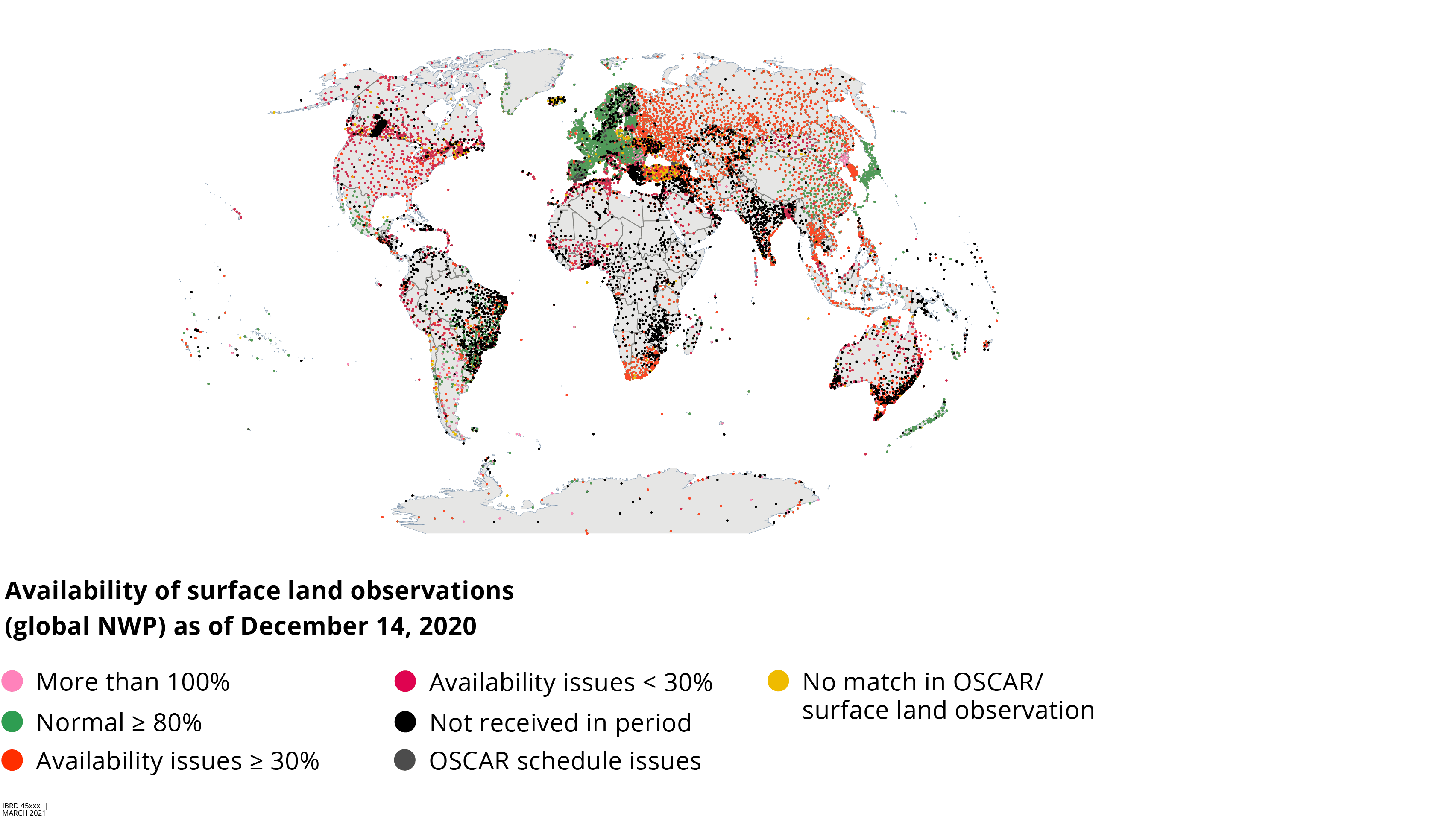
Source: World Bank map, based on data from WDQMS (WIGOS Data Quality Monitoring System) (webtool), World Meteorological Organization, Geneva. Map S4.1.1 data available at the World Bank Data Catalog.
Note: Snapshot of World Meteorological Organization Integrated Global Observing System interactive map showing observations of surface temperature measured on a typical day (December 14) in 2020. NWP = numerical weather prediction; OSCAR = Observing Systems Capability Analysis and Review Tool.
However, these data are not categorized as essential data, as defined by the World Meteorological Organization,6 and are not considered open data from the perspective of their use and reuse. For this reason, RIMES needs to ensure that these data are protected by nondisclosure agreements. In return, ECMWF shares high-resolution digital forecast products with each participating country, with the aim of improving national forecasts and deepening the technical collaboration between RIMES countries and ECMWF. With access to these high-resolution forecast products from ECMWF, countries can focus more efforts on applying forecast information to the needs of their population and on building skills in data analytics.7
As map S4.1.1 shows, significant gaps in reporting basic weather data still exist. Important steps to take are getting countries to recognize the value of sharing their data and to participate in improving the models. In time, it is anticipated that open data policies similar to the European Union Directive will apply to meteorological data everywhere, characterizing these data as having high value for social and economic development. The German Meteorological Service, for example, has started openly sharing all of the data it uses for its public tasks.8 Now more than 500 petabytes of data are downloaded monthly and used by a wide range of industries in Germany to improve their economic performance.
- See Sustainable Development Goals: Decade of Action (dashboard), United Nations
- Hallegatte, Bangalore, and Vogt-Schilb (2016).
- Charts Catalogue (weather map repository), European Centre for Medium-Range Weather Forecasts.
- ECMWF (2018).
- Rimes (2020).
- Zillman (2019).
- ECMWF (2020).
- See Open Data Server (dashboard), Deutscher Wetterdienst.
- ECMWF (European Centre for Medium-Range Weather Forecasts). 2018. “Extra Weather Station Data Improve ECMWF’s Forecasts.” News, June 18, 2018.
- ECMWF (European Centre for Medium-Range Weather Forecasts). 2020. “ECMWF Moves towards a Policy of Open Data.” News, October 7, 2020.
- Hallegatte, Stéphane, Mook Bangalore, and Adrien VogtSchilb. 2016. “Socioeconomic Resilience: Multi-Hazard Estimates in 117 Countries.” Policy Research Working Paper 7886, World Bank, Washington, DC.
- RIMES (Regional Integrated Multi-Hazard Early Warning System for Africa and Asia). 2020. “37 RIMES Countries Agree to Share Data and Focus on Impact Forecasting and Forecast-Based Action for 2021–2025.” RIMES, Asian Institute of Technology, Pathumthani, Thailand, November 26, 2020.
- Zillman, John W. 2019. “Origin, Impact, and Aftermath of WMO Resolution 40.” WMO Bulletin 68 (2): 69–71.